After so many years, I finally made it to the three northeast states (ME, NH and VT) -- to see fall colors. Been to the neighboring NY and MA many times, but going further northeast just didn't happen. With this trip, I have now visited all states of the United States but one - ND. Magic Number is now 1!
Here are some photos of the trip:


Oct 5, 2012 - Soon after we returned to the hotel, it rained heavily. Although there was no rain the next day, it remained foggy most all day near the coast. Sunrise was cancelled again! After a quick breakfast at the hotel, we drove to the main park attraction - Mount Desert Island. First stop - the visitor center. The parking lot is right off ME 3, the main access to the park, but the visitor center is 55 steps up - go figure. Number 1 reason to stop at the visitor center is to use the restrooms. Poor folks had to climb all those steps just for that privilege. We registered at the counter, and they gave us a 7-day tag to hang on our rear view mirror. Supposedly, Park Rangers drive around checking those tags. Also, each time you enter the park, you need to show proof of payment in addition to the tag. Considering the number of people (2.5 million) visiting this park each year, this much scrutiny must be worth it.
Carriage Roads crisscross the park and are closed to cars. There was one next to Jordan Pond. I guess these were more like "developed" trails in this park - for Rockefeller's Horse Carriages. We were finishing up the loop, but the fog was still persistent. We drove up the Cadillac Mountain. Its claim to fame is that, at 1530 feet, it is the highest east coast mountain north of Brazil. Yippy!
The fog was even more dense here. We parked next to the visitor center and walked up on the nearby trail to the top. Of course, there was nothing we could see, and nor were there any other people. We saw a steep trail going down on the opposite side and followed it. Since the road loops around the peak, we were sure to meet it somewhere. We hopped down some distance and saw one couple coming up in the opposite direction. Soon we reached the road and back to our car. This wasn't much of a hike we had in mind. We walked to the other side of the parking lot and finally saw paved trails going in many directions. But you could barely see beyond 100 steps, and there was no way to orient yourself except up or down. We decided to move on. ME 3 loops around on the west side of the park to the Northeast Harbor. This part of the park is quieter and would be a nice place to stay right on the ocean.
Oct 6, 2012 - Next Day, I noticed that Exit 244 would have taken us to Mt Katahdin, the north-most point of the Appalachian Trail ("AT") that goes down to Springer Mountain in Georgia 2180 miles south. Mt Katahdin would have been a fun destination - considering that, at least at the moment, hiking the entire AT is not on my bucket list.
Gorham came quickly - we reached there at 1 PM. Our rooms were not yet ready. Families we were to meet up with at 3 PM were still on their way. We had a nice lunch at an Italian place, Mr Pizza, next door and then drove down on Hwy 16, past Mount Washington Auto Road (planned for Monday), around White Mountains, up north on US 302 to Bretton Woods.
Here are some photos of the trip:
 |
| Fall colors around Mount Washington, NH |
 |
| Reflection in Jordan Pond, Acadia NP |
 |
| Closer view of reflecting colors |
And NOT fall colors.... evergreens in snow on Mount Washington


Oct 3-9, 2012 - This trip was packed in my usual hectic manner - lots of activities but not rushing through any of them. We optimized by flying nonstop on United from SFO leaving at 4 PM Pacific time on Wed 10/3, and reaching BOS at 1 am on 10/4 East Coast time. No big deal, we thought - it was only 10 PM Pacific. We were planning to rent a compact car at the airport and drive up to Acadia National Park (http://www.nps.gov/acad/index.htm) 5 1/2 hours north, to see sunrise at the Cadillac Mountain. That is where the sun rays touch FIRST in the United States. Since we were going to stay just outside Acadia, we would have two more chances - Fri and Sat - to catch the sunrise.
Well, the forecast was for drizzle, rain and fog - for the entire time. Put it another way, "the sunrise was canceled that day." Fall is a tricky time that way, with fog or clouds managing to foil your plans anytime. We had similar experience in the Sierras and Colorado Plateau just the week before. Still, there are always some crazy people like us, who will BE THERE, just in case.
It was drizzly when we landed at BOS, but not too bad. Luckily, there was no fog at that time. Even so, driving at that hour on unfamiliar roads until we got on I-95 was not something to look forward to. Any case, because there was no reason to rush to Acadia to see the sunrise, we decided to drive for an hour or so and stay somewhere for the night.
It was drizzly when we landed at BOS, but not too bad. Luckily, there was no fog at that time. Even so, driving at that hour on unfamiliar roads until we got on I-95 was not something to look forward to. Any case, because there was no reason to rush to Acadia to see the sunrise, we decided to drive for an hour or so and stay somewhere for the night.
National, Alamo and Enterprise rental companies share a common lot at BOS. One shuttle bus took a bunch of us to the rental facility, where the lot was pretty empty - mid-week at 1 am. A woman before us got the last Mustang Convertible. We had a choice of two minivans - Chrysler and KIA. We took the jumbo sized Chrysler Town and Country, fully loaded seven seater van for just the two of us. It is good to rent new cars once in a while to see what new gadgets they have come up with. Just shy of driving themselves YET, these cars seem to do pretty much everything else. Like the joke about "programming the VCR" of the good old days, it can be confusing to explore which buttons do what and where in these cars - especially that late at night when you need to use wipers in a hurry.
Within one hour, we had crossed MA and NH borders, paid tolls along the way on a regular basis, and ended up at Portsmouth, ME for the night. Got up leisurely in the morning, had breakfast in the adjacent restaurant, and avoiding any rush hour traffic, drove up north on I-95 to Acadia NP in Maine. We were tempted to drive up on US Hwy 1 the entire way (which runs almost parallel to I-95), where we finally ended up. Fall colors were in full swing on either side of I-95, and colors got vivider as we drove north.
Checked in to the hotel - Knights Inn Bar Harbor in Hancock - which is neither in Bar Harbor, nor in Hancock. It is just outside Hancock and 18 miles northwest of Bar Harbor, a prime spot adjacent to Acadia NP. First weekend of October is prime time for Fall Colors. Leaves have changed colors, but not yet fallen off the trees. Within a week or two, the brilliant display of colors will fade and be gone, and trees be barren - starting at the top. All hotels in the surrounding 50 mile radius of Acadia were sold out for the weekend. Weather-wise, this wasn't the best weekend and we didn't notice huge crowds - at least until we left Saturday morning.
Knights Inn is situated on a hillside bluff with most rooms facing East. If the weather was clear, we would see the Atlantic Ocean, Cadillac Mountain, and of course, sunrise right from our room. Today, with fog, we could barely see half a mile out.
Knights Inn is situated on a hillside bluff with most rooms facing East. If the weather was clear, we would see the Atlantic Ocean, Cadillac Mountain, and of course, sunrise right from our room. Today, with fog, we could barely see half a mile out.
Switching our plans around a bit, we spent Thursday afternoon visiting the Schoodic Peninsula, which is part of Acadia NP but completely disconnected and 45 miles further north, around Frenchman Bay. Driving on two lane roads is now a favorite pastime of mine - they move pretty well, and you get a chance to see the small towns along the way. Schoodic is pretty scenic, but there are no fall colors near the ocean. It is all evergreens, like in the Sierras in the west. One way roads within the park were very quiet, with only a handful of cars like us making frequent stops and taking pictures. Fog lingered most of the day so the far away pictures of Mount Desert Island weren't that dramatic. Most of the coastline displays massive granite rocks, cracked in to boulders that you can jump over and around all you want. Occasionally, black lava (diabase dikes) squeezed its way through the cracks in granite for special effects. At one vista point, we were able to walk up to the water. It wasn't that cold to touch, though not for a swim. There was not much wildlife in the park that we saw. In two days, we only saw two deer waiting to cross the road. We stopped to let them cross, but they wanted us to go first!
Acadia is the only National Park created from the private lands donated to the government, and was therefore a patchwork of a park as late as 1986. Even now, access roads to the park go through private lands and towns.
At the hotel, they suggested Ruth and Wimpy's as a popular restaurant for lobster and seafood. We stopped on our return from Schoodic to check it out. The place was popular - with locals as well as tourists it seemed. We enjoyed fresh lobster, corn and (not fresh) blueberry pie. Blueberry season ends in August, but there were plenty of (other) berry shrubs all around the park.
Oct 5, 2012 - Soon after we returned to the hotel, it rained heavily. Although there was no rain the next day, it remained foggy most all day near the coast. Sunrise was cancelled again! After a quick breakfast at the hotel, we drove to the main park attraction - Mount Desert Island. First stop - the visitor center. The parking lot is right off ME 3, the main access to the park, but the visitor center is 55 steps up - go figure. Number 1 reason to stop at the visitor center is to use the restrooms. Poor folks had to climb all those steps just for that privilege. We registered at the counter, and they gave us a 7-day tag to hang on our rear view mirror. Supposedly, Park Rangers drive around checking those tags. Also, each time you enter the park, you need to show proof of payment in addition to the tag. Considering the number of people (2.5 million) visiting this park each year, this much scrutiny must be worth it.
We picked up the colorful map from the visitor center and followed the Park Loop road clockwise the entire way through. Cadillac Mountain road was at the tail end of the loop. We were hoping that by the time we finish the loop, skies may clear. First was Sand Beach - a narrow quiet beach in an alcove. The water was pretty quiet, and colder. There were no developed trails on any sides that we saw. People just strolled around for a while before moving on. Next is Thunder Hole. Again, lot of granite rocks to hop over and around. Of course, there is a paved wheelchair accessible path that takes you close to the Thunder Hole, which thunders only when the seas are rough. Not today. More views and rock hopping at Otter Point; after which the Loop Road turns inland. There are several lakes - called glacier-carved ponds - on this island. There is a nice restaurant next to Jordan Pond with outdoor seating for lunch. A 3 mile level trail loops around the Pond. We went almost half way around, but the latter part was entirely narrow board walk - you really have to be looking down the entire time and watch your steps. No fun! So we turned around.
The fog was even more dense here. We parked next to the visitor center and walked up on the nearby trail to the top. Of course, there was nothing we could see, and nor were there any other people. We saw a steep trail going down on the opposite side and followed it. Since the road loops around the peak, we were sure to meet it somewhere. We hopped down some distance and saw one couple coming up in the opposite direction. Soon we reached the road and back to our car. This wasn't much of a hike we had in mind. We walked to the other side of the parking lot and finally saw paved trails going in many directions. But you could barely see beyond 100 steps, and there was no way to orient yourself except up or down. We decided to move on. ME 3 loops around on the west side of the park to the Northeast Harbor. This part of the park is quieter and would be a nice place to stay right on the ocean.
I had asked the front desk at our hotel about "things to do around Acadia," other than the park itself - "Not much really" was the answer. "If you want to see fall colors, just drive up I-95." We had already done that partly from Boston to Bangor. It was another 100+ miles to the Canadian border. As soon as we left Acadia and started driving west towards Bangor, skies started to clear and the rest of the afternoon was sunny. We drove up north of Bangor. Watching colors is fun on I-95, but there were no places to stop and take pictures. By Exit 217, colors were fading and trees were already barren. So we took that Exit and drove on ME 6 West and then ME 15 South back to Bangor. But now these roads were pretty narrow with no places to stop. We looked for bridges over streams near which we could stop and took photos.
Back in Bangor, we found Apple bee's and their famous 2 for $20 dinner. They have interesting menu items all the time. When it came time to tipping, we talked about how people figure out how much to tip. In California, a simple way is to double the tax amount on your bill. Well, that wouldn't work in ME (or NH or VT, for that matter.) At Apple bee's, the tax was only $1.85 or something.
How do YOU tip? I know someone who simply takes the first digit of the bill and doubles it. For example, if the bill is $30 something, he would tip $6 (double the first number, 3) If the bill was close to $30, he would have tipped 20%, whereas if it was closer to $40, then it is 15%. I normally make the cents 00 including the tip (round to the next dollar) - this was useful when paying cash; with credit card, it doesn't really matter. Someone else reverses the first two numbers for cents, like $26.62 Whatever you do, tip well. As you know, most waiters barely make the minimum wage including tips. So what if you paid a dollar or two more?
Oct 6, 2012 - Next Day, I noticed that Exit 244 would have taken us to Mt Katahdin, the north-most point of the Appalachian Trail ("AT") that goes down to Springer Mountain in Georgia 2180 miles south. Mt Katahdin would have been a fun destination - considering that, at least at the moment, hiking the entire AT is not on my bucket list.
On Saturday Oct 6, no sunrise again. Our drive today was nearly straight west - first to Bangor, then on I-95 to Exit 157 and then US Hwy 2 all the way to Gorham, NH, where we were to meet a couple of families for the weekend. Clouds were rolling in and out, with occasional sprinkle or two. We were told to look for two attractions on Hwy 2 in Maine, but on that two lane road, we missed them both. One was Spring Valley water bottling plant, and another New Balance Factory Store in Skowhegan. We actually stopped at Skowhegan to take some pictures, but didn't even think to look for the store.
Mount Washington Resort, run by Omni Hotels, is the site of the famous Bretton Woods Gold Conference back in July 1944. For those in the Finance field, Bretton Woods has a historical significance. Those with Gold Bug would also know Bretton Woods for the Gold Standard, and its eventual collapse in the 70's.
As Europe and Japan were rebuilt and their economies became self sustaining, US could no longer continue to convert US dollar for equivalent gold. On 15 August 1971, the United States unilaterally terminated convertibility of the US$ to gold. This brought the Bretton Woods system to an end and saw the dollar become a fiat currency. This action, referred to as the Nixon shock, created the situation in which the United States dollar became a reserve currency used by many countries. At the same time, many fixed currencies (such as GBP), became free floating. Today, no country is on gold standard; more currencies have become free floating; and thanks to international monetary cooperation, the world is becoming "global."

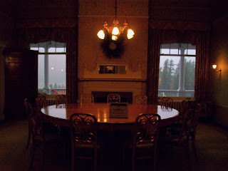 This five star hotel is very impressive and worth visiting. To this day, the room called the Gold Room, with gold table and chairs, is open for public viewing as the location of the Gold Conference. Surely, 730 delegates were not in this room at one time.
Light rain fell when we reached the hotel. Lots of visitors were coming in just to look around. In addition, there were the hotel guests, and a wedding ceremony later in the evening. Out of curiosity, I checked the room rates for October 31 for a room with queen bed and breakfast included - $152 per night. Definitely worth staying here some day!
We walked around the hotel balconies for nice views of the swimming pool, creek, and a golf course beyond. Even in the fog, we could see colorful mountains further out. By the time we were ready to leave the hotel, it was pouring heavily. We waited for it to subside and then drove back to Gorham.
Royalty Inn was one of the three hotels in town. All were pretty booked for this weekend -but other hotels were scheduled to close for winter in about two weeks. Our hotel had attached indoor gym, 25 meter heated pool and hot tub. Of course, I couldn't resist and went swimming that day and the next. Other than during the family time, the pool was pretty quiet.
We had inquired about hiking trails around, and were told that there were numerous. In fact, AT (Appalachian Trail) passes by Mount Washington which we visited on Sunday. In general, the trails were poorly marked, and with falling leaves, very difficult find/retrace.
Oct 7, 2012 - Next morning, the sky was partly clear, and we hoped to hike the hill adjacent to town. We couldn't even see that hill the previous day due to fog. We followed the directions they gave us - "go past the church, behind the cemetery and you'll see the sign for the trail." Well, we saw the sign for the trail, but not the trail itself. We just hiked around elsewhere, and set out for Franconia Notch area. This is the best Notch around White Mountains, with many hiking trails, waterfalls, lakes and Aerial tramway (ski lift during winter season; for just viewing, the rest of the time.) The weather was once again - partly sunny, partly cloudy, some rain and fog. Not necessarily the best for viewing from top of the Tramway - so we skipped that, and took various other hikes taking pictures of trees, waterfalls, The Basin, Echo Lake and Vista Point. Not too far to the west, Connecticut River serves as the boundary between NH and VT, and a few miles past that is Montpelier, capital of VT. US 302 would take us there, and US 2 would bring us back to Gorham. Per AAA guidebook, Vermont is also famous for its fall colors, so we decided to check it out. The drive was pretty scenic, but you could tell that the homes and roads were a notch or two below those in NH - noticeable financial gap between two states. Being Sunday, Montpelier was relatively quiet. Even with free parking meters on Sundays, we could park right in front of the Capitol Building to take pictures, and stop at the visitor center. After a quick bite to eat, we returned back to Gorham for the evening. As usual, it got cloudy and rained in the evening.
Oct 8, 2012 - Monday, October 8 was Columbus Day. Governments and Banks were off, but not too many businesses. It was only later in the day that we would have to face commute traffic, if any. The morning was partially clear and sunny. Just as we were getting up, power went out (for unknown reason, and didn't come back up until several hours later, including at Mount Washington.) With no power, we couldn't really do anything in the room. The front office as well as McDonald's couldn't serve any coffee or food. Other hotel guests rushed out several miles west to Walmart to get their coffee and donuts. Nobody was happy. We decided to just hop in the car, and as planned, drive to Mount Washington about 8 miles south.
It had snowed on Mount Washington the previous night. Mount Washington Auto Road was closed after the first 4 miles. This is a privately owned "attraction" hailed as the first public attraction in the US, or some claim to fame like that. This 8 mile steep road was built initially with hand tools, and is now nice paved two lane road to the top. The entrance fee is pretty steep too - $25 for the car/driver, plus $8 per additional person. Alternatively, you could park just outside the park and hop in to their shuttle buses for $29 per person. At the entrance, they told us about the partial closure and charged only $25. Having come so close, we might as well go as far as we could. We had passed by Mount Washington on Saturday, and even at that time, we could not see the top - so we didn't miss much. We still got some amazing pictures. There were very few cars at that time, so we could stop along the way and take pictures even where there were no pullouts. When we reached road closure point, several (5-6) shuttles came right behind us bringing crowds. There were a few areas where you could walk up to the edge to take photos, but otherwise, the snow cover was deep enough for us to venture beyond. One brave jogger had climbed up to that point.
On the way down, we saw the Appalachian Trail "AT" cross the road - Photo Op! One of the shuttles had stopped at a vista point on the way down, so we stopped too. It wasn't that cold, windy or rainy, but folks in the shuttle buses did not want to get down, so they were handing their cameras to the driver who was taking pictures for them! We couldn't see the top of Mount Washington, but cog railway comes to the top from the opposite (West) side - from Bretton Woods. There is an observatory on top, and on a clear day, you can see 300 miles - Canada to the north, and several states around. We just imagined the view!
Because of the steepness, we were advised to keep the car in the low gears (#1) the entire time. For the entrance fee paid, you get a certificate of visiting Mount Washington, a bumper sticker, and a CD. You are supposed to listen to the CD on the way up and down. At the exit, you could return it if you wanted to. We kept it because we had not listened to it. On it was the history of Mount Washington, the Auto Road (was a carriage road before that!) From time to time, they have race cars race to the top. The record is 8 minutes, going at 200 mph. And yet we were asked to drive in the first gear!
Mission accomplished, we drove back up to Gorham for a quick break, and took our favorite US Hwy 2 West to NH-VT border and then I-91 South. We stopped in Hanover, NH to visit Dartmouth University, had lunch at Molly's, and then continued south. Near NH/VT/MA border, there were protesters with NO NUKES signs on every overpass for several miles. Crossing 40 miles of MA, we then entered CT and drove almost all the way to the ocean where we ended on I-95. We hit evening commute traffic in every city along the way, but car pool lanes saved us a couple of times. I-95 south took us to Norwalk, CT, our destination for the night. We reached just as it was getting dark - though it took much longer than expected due to traffic.
Oct 9, 2012 - Next morning, after all the commute traffic was gone, we left Norwalk at 10 am and drove back to Boston about 3 hours away. Our flights were at 3 PM. We reached BOS at 1 PM, returned the rental car, checked in baggage and relaxed for a while. Security lines didn't look that bad, but it took us one hour just to go through Security - horrible. Because the lines were so slow, they would announce flights that were about to leave and take those passengers ahead of us, which slowed us further. GO TSA!
Thank goodness, the flights left on time and the rest of the journey was uneventful.
All in all, despite iffy weather, we were able to do and see the things we wanted to. Even behind our house, there are maple trees which are changing colors right now. We also saw fall colors in Jackson, WY near Grand Tetons. But seeing mountains after mountains in multitudes of colors, and on both sides of roads and highways, and on trails, is an amazing experience. I am glad it worked out!
For other blogs, click: http://kanitkar.blogspot.com/2009/11/travel-adventures.html
Preparing to rebuild the international economic system while World War II was still raging, 730 delegates from all 44 Allied nations gathered at this Hotel in Bretton Woods, New Hampshire for the United Nations Monetary and Financial Conference. Delegates deliberated during 1–22 July 1944, and signed the Agreement on its final day.
Since much of Europe and East Asia was devastated by the war, and had used up their gold reserves to pay for war efforts, a new system was needed to handle international payments. US owned most of the gold, and was ready to assume the role of world currency, one that British Pound (GBP) held for over a century previously. Gold price was set at US $35 an ounce, and fixed exchange rates were set against the US dollar. US promised to convert dollars for equivalent gold upon request. Therefore, US dollar became accepted pretty much worldwide.
Through re-building programs like the Marshall Plan, huge grants were provided to Europe and Japan. These funds were used to pay for buying products and services from US multinational companies, who had built up huge manufacturing capacity during the war effort.
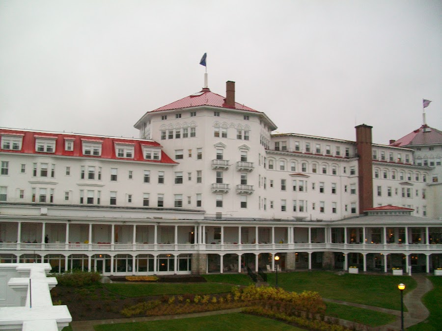 |
| Mount Washington Resort, Bretton Woods, NH |
Light rain fell when we reached the hotel. Lots of visitors were coming in just to look around. In addition, there were the hotel guests, and a wedding ceremony later in the evening. Out of curiosity, I checked the room rates for October 31 for a room with queen bed and breakfast included - $152 per night. Definitely worth staying here some day!
We walked around the hotel balconies for nice views of the swimming pool, creek, and a golf course beyond. Even in the fog, we could see colorful mountains further out. By the time we were ready to leave the hotel, it was pouring heavily. We waited for it to subside and then drove back to Gorham.
Royalty Inn was one of the three hotels in town. All were pretty booked for this weekend -but other hotels were scheduled to close for winter in about two weeks. Our hotel had attached indoor gym, 25 meter heated pool and hot tub. Of course, I couldn't resist and went swimming that day and the next. Other than during the family time, the pool was pretty quiet.
We had inquired about hiking trails around, and were told that there were numerous. In fact, AT (Appalachian Trail) passes by Mount Washington which we visited on Sunday. In general, the trails were poorly marked, and with falling leaves, very difficult find/retrace.
Oct 7, 2012 - Next morning, the sky was partly clear, and we hoped to hike the hill adjacent to town. We couldn't even see that hill the previous day due to fog. We followed the directions they gave us - "go past the church, behind the cemetery and you'll see the sign for the trail." Well, we saw the sign for the trail, but not the trail itself. We just hiked around elsewhere, and set out for Franconia Notch area. This is the best Notch around White Mountains, with many hiking trails, waterfalls, lakes and Aerial tramway (ski lift during winter season; for just viewing, the rest of the time.) The weather was once again - partly sunny, partly cloudy, some rain and fog. Not necessarily the best for viewing from top of the Tramway - so we skipped that, and took various other hikes taking pictures of trees, waterfalls, The Basin, Echo Lake and Vista Point. Not too far to the west, Connecticut River serves as the boundary between NH and VT, and a few miles past that is Montpelier, capital of VT. US 302 would take us there, and US 2 would bring us back to Gorham. Per AAA guidebook, Vermont is also famous for its fall colors, so we decided to check it out. The drive was pretty scenic, but you could tell that the homes and roads were a notch or two below those in NH - noticeable financial gap between two states. Being Sunday, Montpelier was relatively quiet. Even with free parking meters on Sundays, we could park right in front of the Capitol Building to take pictures, and stop at the visitor center. After a quick bite to eat, we returned back to Gorham for the evening. As usual, it got cloudy and rained in the evening.
Oct 8, 2012 - Monday, October 8 was Columbus Day. Governments and Banks were off, but not too many businesses. It was only later in the day that we would have to face commute traffic, if any. The morning was partially clear and sunny. Just as we were getting up, power went out (for unknown reason, and didn't come back up until several hours later, including at Mount Washington.) With no power, we couldn't really do anything in the room. The front office as well as McDonald's couldn't serve any coffee or food. Other hotel guests rushed out several miles west to Walmart to get their coffee and donuts. Nobody was happy. We decided to just hop in the car, and as planned, drive to Mount Washington about 8 miles south.
It had snowed on Mount Washington the previous night. Mount Washington Auto Road was closed after the first 4 miles. This is a privately owned "attraction" hailed as the first public attraction in the US, or some claim to fame like that. This 8 mile steep road was built initially with hand tools, and is now nice paved two lane road to the top. The entrance fee is pretty steep too - $25 for the car/driver, plus $8 per additional person. Alternatively, you could park just outside the park and hop in to their shuttle buses for $29 per person. At the entrance, they told us about the partial closure and charged only $25. Having come so close, we might as well go as far as we could. We had passed by Mount Washington on Saturday, and even at that time, we could not see the top - so we didn't miss much. We still got some amazing pictures. There were very few cars at that time, so we could stop along the way and take pictures even where there were no pullouts. When we reached road closure point, several (5-6) shuttles came right behind us bringing crowds. There were a few areas where you could walk up to the edge to take photos, but otherwise, the snow cover was deep enough for us to venture beyond. One brave jogger had climbed up to that point.
On the way down, we saw the Appalachian Trail "AT" cross the road - Photo Op! One of the shuttles had stopped at a vista point on the way down, so we stopped too. It wasn't that cold, windy or rainy, but folks in the shuttle buses did not want to get down, so they were handing their cameras to the driver who was taking pictures for them! We couldn't see the top of Mount Washington, but cog railway comes to the top from the opposite (West) side - from Bretton Woods. There is an observatory on top, and on a clear day, you can see 300 miles - Canada to the north, and several states around. We just imagined the view!
Because of the steepness, we were advised to keep the car in the low gears (#1) the entire time. For the entrance fee paid, you get a certificate of visiting Mount Washington, a bumper sticker, and a CD. You are supposed to listen to the CD on the way up and down. At the exit, you could return it if you wanted to. We kept it because we had not listened to it. On it was the history of Mount Washington, the Auto Road (was a carriage road before that!) From time to time, they have race cars race to the top. The record is 8 minutes, going at 200 mph. And yet we were asked to drive in the first gear!
Mission accomplished, we drove back up to Gorham for a quick break, and took our favorite US Hwy 2 West to NH-VT border and then I-91 South. We stopped in Hanover, NH to visit Dartmouth University, had lunch at Molly's, and then continued south. Near NH/VT/MA border, there were protesters with NO NUKES signs on every overpass for several miles. Crossing 40 miles of MA, we then entered CT and drove almost all the way to the ocean where we ended on I-95. We hit evening commute traffic in every city along the way, but car pool lanes saved us a couple of times. I-95 south took us to Norwalk, CT, our destination for the night. We reached just as it was getting dark - though it took much longer than expected due to traffic.
Oct 9, 2012 - Next morning, after all the commute traffic was gone, we left Norwalk at 10 am and drove back to Boston about 3 hours away. Our flights were at 3 PM. We reached BOS at 1 PM, returned the rental car, checked in baggage and relaxed for a while. Security lines didn't look that bad, but it took us one hour just to go through Security - horrible. Because the lines were so slow, they would announce flights that were about to leave and take those passengers ahead of us, which slowed us further. GO TSA!
Thank goodness, the flights left on time and the rest of the journey was uneventful.
All in all, despite iffy weather, we were able to do and see the things we wanted to. Even behind our house, there are maple trees which are changing colors right now. We also saw fall colors in Jackson, WY near Grand Tetons. But seeing mountains after mountains in multitudes of colors, and on both sides of roads and highways, and on trails, is an amazing experience. I am glad it worked out!
For other blogs, click: http://kanitkar.blogspot.com/2009/11/travel-adventures.html